|
|
|
PredictWind Announces New Weather
Routing Algorithm
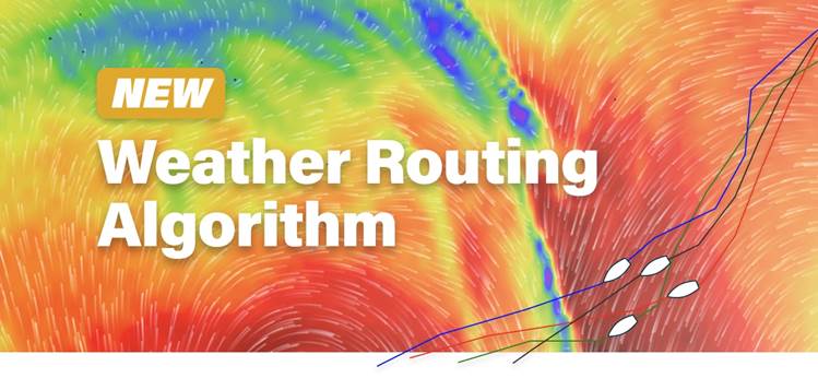
Completely new code that offers
unparalleled performance
 5 years of development have gone into the
production of their new game-changing weather routing. Each route
executes over a billion calculations on the PredictWind servers which gives
superior results. Jon Bilger, PredictWind CEO stated, “We set out to make a
better weather router than has ever been seen before, and we achieved that.” Going further, Bilger continued “We didn’t just want to be able to say the
router is better, we wanted to prove it. We did an extensive study comparing
other widely used weather routing tools, whereby all routes were back tested to
be validated, and we were very impressed with the outcome for the new
PredictWind weather router”. 5 years of development have gone into the
production of their new game-changing weather routing. Each route
executes over a billion calculations on the PredictWind servers which gives
superior results. Jon Bilger, PredictWind CEO stated, “We set out to make a
better weather router than has ever been seen before, and we achieved that.” Going further, Bilger continued “We didn’t just want to be able to say the
router is better, we wanted to prove it. We did an extensive study comparing
other widely used weather routing tools, whereby all routes were back tested to
be validated, and we were very impressed with the outcome for the new
PredictWind weather router”.
The Key Features of the New PredictWind Router are:
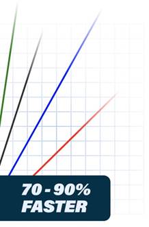
Fastest Routes -
The new routing engine finds the fastest routes 70-90% of the time, compared to
our competition. We tested the new PredictWind router against the competition,
by using the same boat polar, the same wind field and then evaluated the
optimal routes through a sailing simulator to actually see which routing engine
sailed the boat fastest to the destination. The new PredictWind router was a
clear winner! Check the technical report for
details.
Routing Corridors - The new router shows “routing corridors” along with the optimal
route. These corridors show an area where the boat can reach the
destination within 0.1% of the fastest time. Routing a boat on the water is a
very different situation to a GPS car navigation route. The boat route is only
as accurate as the weather forecast and the boat’s polars. The routing
corridors show areas where it is imperative to be close to the optimal route
and other areas where you can deviate a long way from the optimal route.
Overlapping areas between the four routes based on forecasts from four
different sources gives you a high degree of confidence in the route to sail.
This new concept will revolutionize how optimal routes are viewed.
Accurate Weather - Every PredictWind route is calculated using the highest resolution ECMWF/
Spire/ UKMO/ GFS/ PWG and PWE forecast data. ECMWF is proven to be the most
accurate weather model from a national weather service but is being challenged
by the new Spire model. The high resolution PredictWind models that are run at
1 km/8 km resolution are the highest resolution models available with proven
accuracy in the short term. Getting 6 forecasts for every route gives you
additional confidence in the forecast.
Speed & Ease - As the PredictWind router is run on cloud computing, it is not essential to
download GRIB files to calculate a route. In some circumstances, this will save
you at least 50 MB of GRIB downloads. The PredictWind router has access to the
highest resolution GRIB data for wind, wave and current. To download this data
on a mobile or satellite connection is very slow and expensive. With the click
of a button, the forecasts for all 4 forecast models are quickly and easily
displayed to help make informed decisions.
Long-Range Forecasts
- We have added the ECMWF ensemble forecasts with an incredible
long-range 4-week forecast. The ECMWF ensemble is unequivocally the leader in
long-range forecasting and will let you plan your trip well in advance, with
better accuracy than traditional climate forecasts.
Reliable - The PredictWind router works. No failed routes, or issues with the route
crossing land, so you can concentrate on sailing the boat. Check the technical report for
the reliability of the new PredictWind Router.
Detailed Feature List
- Weather
routing with a grid-based, highly optimized algorithm.
- Fast
execution time as 4 routes are calculated parallel.
- Considers
wind, currents and waves.
- Uses
the highest resolution GRIB data wherever available.
- Automatically
covers the entire globe.
- Effective
land avoidance.
- Considers
all exclusion zones supplied.
- Provides
both optimal weather routing and comfort routing.
- Advanced
boat polar extrapolation.
- Allows
a course to have both waypoints and roundings.
- Display
of the overlap of such corridors to show passages where the ensemble of
weather forecasts agree that it is optimal to pass.
- Numerous
data available along the route: wind, currents, waves, speed, distances,
angles, times, air pressure, temp, rain, CAPE index.
- Continuous
interpolation of these data along the route.
- Presentation
of motoring time in comfort routing.
- Choose
the Ocean Current data source.
- Router
finds a route when start & destination waypoints are on the land.
- Wave
and Ocean data available along the coastline.
- Yacht
tacking & gybe angles are accurately respected.
- ECMWF
routes use the 9 km resolution wind data & 14 km wave data.
Attention Sailing Organizations & PR Agencies:
Add us to your distribution list, contact us today
|
|
